Throughout B.C.’s wide range of watershed types, common issues with watershed condition emerge.
Watershed disturbance has resulted from activities including resource extraction, road construction, motorized recreation, range use, wildlife, slope failures, forest pests, and wildfire. In addition to impacting water quality, the disturbance has resulted in increased runoff that has altered channels, increased slope failures, and damaged infrastructure.
These threats to drinking water supplies are amplified by climate change. Warmer, drier summers followed by milder, wetter winters with more extreme storm events throughout the year are predicted in climate modelling. Warmer summers mean more wildfires, and greater demand on water resources with greater risk of drought. Milder, wetter winters can provide more water but storage has to be developed to make this useful. Extreme weather events increase the risk of flooding. These climate change effects combined with lowered watershed resilience put increased strain on water resources.
While threats are often thought of individually, their cumulative impacts must be considered. Source water protection not only addresses the cumulative impacts of these hazards, it can also lead to cumulative benefits for communities.
As an example, the aerial image below (Figure 9), taken during the 2003 Okanagan Mountain wildfire, shows the level of disturbance in the Okanagan watershed. This image demonstrates the levels of urban disturbance near Okanagan Lake as well as cut block disturbance further back in its watersheds. These watersheds have been altered hydrologically over time. Their altered hydrology reflects the amount of watershed disturbance (roads, cutblocks, trails, quarries) and the proximity of disturbance to source water resources.
Figure 9: Okanagan Valley showing watershed disturbance
(watercourses highlighted in blue)
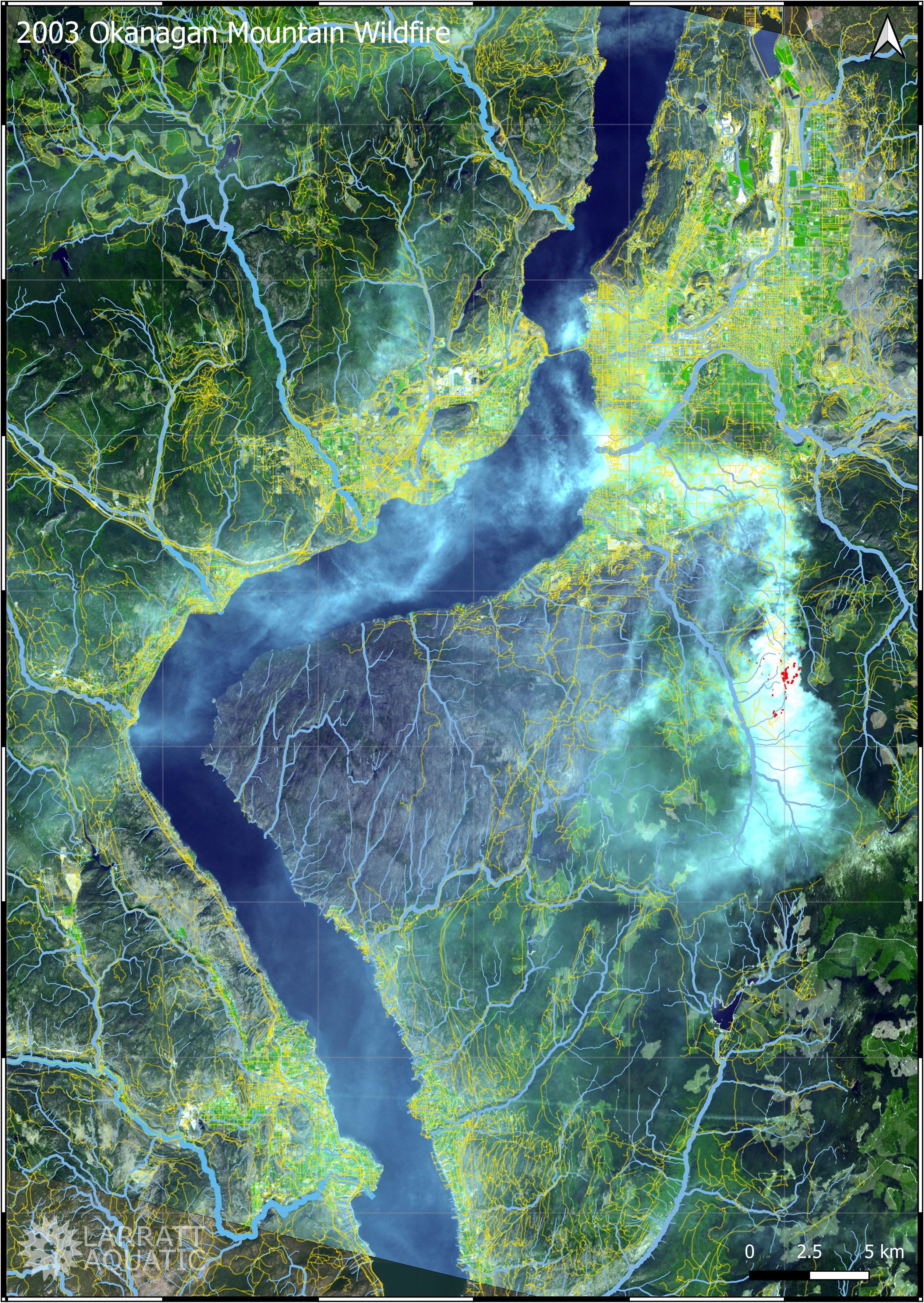
(watercourses highlighted in blue)
Pro Tip: Use the Google Maps time slider to see the changes over the decades in your watershed.
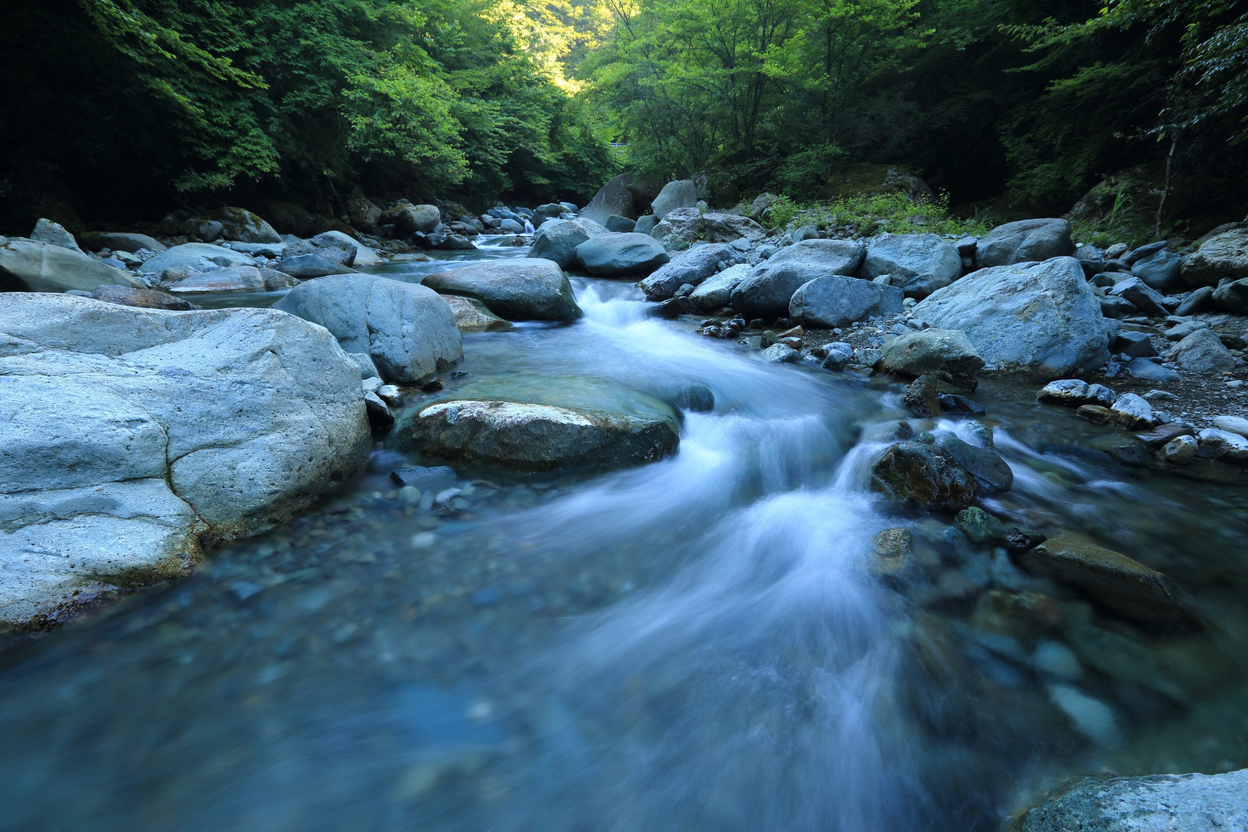
Surface Water
As source water flows through rural areas, contaminants are commonly introduced by agricultural runoff, grazed riparian areas, unmanaged stormwater/road runoff, and septage. Activities on the rural landscape also pose hazards to groundwater sources, as these lower lying areas often encompass recharge zones. In urban areas, source water may accumulate contaminants from transportation, light industrial and residential sources, as well as from new land developments. The hardened urban landscape is mostly impervious, which creates more runoff than undeveloped land, limits natural filtration of contaminants, and directs runoff to stormwater drains and ultimately mainstem lakes.
The mainstem lakes in the Okanagan bear the brunt of it all. Not only are these source lakes subject to the quality of creek inflows and stormwater outfalls, they are also susceptible to adjacent land use, invasive species, algal blooms, marina activities, and boating impacts.
Threats to surface water that are common to most watersheds are summarized in Table 22 and solutions to overcome them are provided in Table 23.
Table 22: Cumulative effects of watershed stressors on surface water
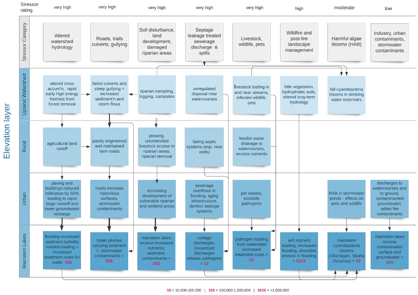
Table 23: Surface water – solutions to overcome watershed condition obstacles
Obstacle
Solution
Suggested Implementation
Altered watershed hydrology (e.g., increased peak flows due to loss of tree canopy; earlier freshets due to altered runoff from road network)
Cap percentage of active disturbance ranked by proximity to streams and cap total watershed area in disturbance, defined hydrologically.
Push for integrated watershed planning led by one lead water agency. Insist that hydrologic assessments are cumulative and consider all watershed disturbances through time.
Roads, trails, culverts, gullying
Fund permanent road closures that can’t be reopened (e.g., deep cross-ditches, barricades, bridge removals).
Reach out to B.C. FPB for assistance locating forest licensee to provide your input to deactivation prescriptions. See Engineering Manual 2019 FLNRORD chpt 7 for BMP’s.
Soil disturbance, land development, damaged riparian areas
Establish protected areas where stakeholders share responsibility to protect and benefits.
Develop policies, bylaws, agreements to protect key areas that have potential to impact the water supply. Demonstrate the long-term economics through natural asset valuation, and monitor success.
Septage, treated wastewater discharge, spills
Consider monitoring data to guide best disposal. Educate residents on what NOT to flush.
Consider package water treatment plants or composting toilets to replace shoreline septic in remote areas.
Livestock, wildlife, pets
Use fencing or other diversions to guide animals to safe off-stream watering area.
Install watering troughs and fence/plant unstable slopes.
Harmful algae blooms
Reduce phosphorus reporting to the lake from its watershed.
Reduce nutrient applications to landscape. Install ‘green belts’ of willow, cottonwood, aspen, and/or poplar that rapidly uptake nutrients.
Industry / urban / stormwater contaminants
Assess monitoring data to prioritize stormwater treatment (e.g., treatment ponds, diversion, on-site water treatment, and on-site rainwater soak-away).
Using stormwater BMPs, start work with highest priority contaminant abatement. Monitor and report success. Incentivize rain gardens, rain barrels, soak-away zones where slopes allow.
Groundwater
Groundwater is an important part of the hydrologic cycle. It receives, stores, transports, and discharges precipitation and is intertwined with surface water. Extracting water from either supply can decrease the supply in the other source. As in most regions in BC, much less is known about Okanagan groundwater than surface water.
Information gaps include:
- Size of the aquifer and rate of recharge
- Location and size of groundwater recharge zones
- Water travel time in the aquifer
- Type of aquifer (i.e., confined or unconfined)
- Vulnerability to contamination sources (e.g., agriculture; waste disposal sites, storage tanks, transportation routes)
- Potential for natural attenuation of contaminants within the groundwater
- Contribution of groundwater to streams to maintain surface water baseflows during dry weather
The biggest obstacle to effective groundwater protection is the lack of coordinated land use planning over aquifers. This is further complicated by a lack of accurate information on aquifer locations.
Threats to groundwater that are common to most watersheds are summarized in Table 24 and solutions to address the threats are provided in Table 25.
Table 24: Cumulative effects of watershed stressors on groundwater
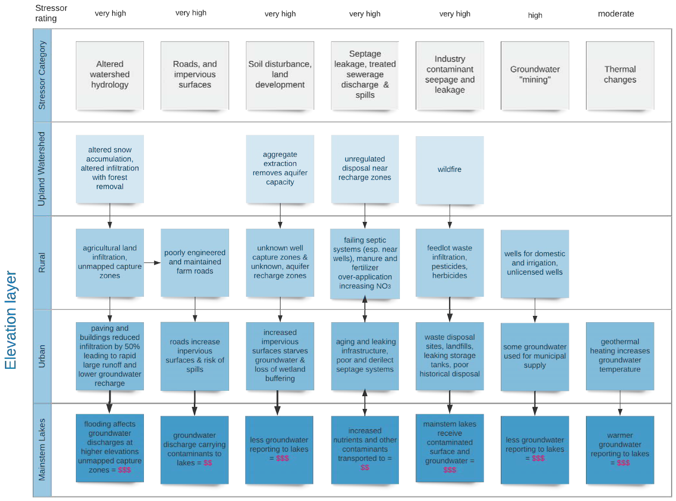
Table 25: Groundwater – solutions to overcome watershed condition obstacles
Obstacle
Solution
Suggested Implementation
Recharge zones not identified
Do groundwater studies to delineate recharge zones
Local governments post signs showing maps of recharge zones and inform affected land-owners
Gravel quarries in recharge zones
Limit new permitting, request compensation for lost hydrologic buffering
MMPR can inform local governments when permit applications are received for recharge zone areas. Consult https://www2.gov.bc.ca/assets/gov/driving-and-transportation/transportation-infrastructure/contracting-with-the-province/documents/16925-2020/t3-2-aggregate-operators-best-management-practices-handbook-volume-1.pdf
Wells not identified
Continue to support BC’s well registry program (1st in time – 1st in right)
Water supply associations and local governments can continue to supply links for well registry in their communications well registration form (PDF)
Lack of quality and quantity data
Ask for permission to sample and for data donations from registered well owners
Collaborate with IHA, FLNRORD and other entities to help maintain/develop the groundwater well network: https://www2.gov.bc.ca/gov/content/environment/air-land-water/water/groundwater-wells-aquifers/groundwater-observation-well-network
Historical disposal sites
Identify, map and address contaminant plumes via remediation (e.g., capping, contaminant removal, in-situ treatment)
For guidance and resources consult: https://www2.gov.bc.ca/gov/content/environment/air-land-water/site-remediation/guidance-resources
A special note on forest and range disturbances
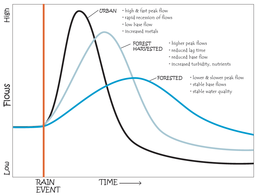
Water supplies and watersheds are inseparable. Forest disturbance by harvesting, roads, fire, insects, disease or motorized recreation can result in a variety of hydrological effects through changes to snow accumulation, rainfall infiltration, and snowmelt rate. Depending on site conditions, high rates of disturbance can result in channel erosion, debris flows and floods, and these in turn affect the quality, quantity and timing of water reaching a water supply intake. Although a variety of forest disturbances can affect watershed hydrology, forest licensees can only control forest harvesting and access roads. Watershed hydrology determines water supply availability and reliability as explained in Figure 10.
Figure 10: Comparison of hydrographs in forested (upland watershed), forest harvested and urban watersheds
Water suppliers can influence forest and range activities in source watersheds by doing the following:
- Get to know the forest and range users operating in your source watershed. If you are unsure about who has a licence to conduct forest or range activities, contact the District Office in your Natural Resource District of the Ministry of Forests, Lands, Natural Resource Operations and Rural Development.
- Develop working relationships with forestry and range users. Let them know the concerns you have about the protection of water quality and quantity in the watershed. Document your interactions.
- Let forest licensees know that you would like to be notified when their forest stewardship plan (FSP) is up for renewal. (An FSP is a map-based, landscape-level plan of potential forest development activities that are intended to take place in the plan area. They have 5-year terms and may be renewed for additional terms.) Forest licensees are obligated to consider (but not required to act upon) water purveyor concerns about potential impacts on water quality.
- Ask licensees to explain their planning process and when they hire a professional hydrologist to conduct a hydrological assessment. Let them know you would like to receive a copy of any hydrological assessment reports and to have an opportunity for review and comment (see Table 26). Every hydrological assessment should discuss whether, and to what extent, forest harvesting or road construction will affect water quality and quantity or timing of flow to the intake (i.e., where water is diverted for drinking).
- Ask licensees to explain how they manage riparian areas, how they plan and design roads to minimize erosion, and how they practice erosion and sediment control on all roads.
Table 26: Elements to look for in a hydrological assessment
1 SCOPING
2 METHODS & ASSESSMENT
3 SYNTHESIS
4 CUMULATIVE HYDROLOGIC EFFECTS
5 SOLUTIONS & ADAPTIVE MANAGEMENT
The report should include the full scope of potential impacts of cutblocks, roads, and stream crossings on water, soils, slope stability, channels, wildlife, vegetation, diversity.
The report should provide evaluation methods so the findings can be assessed. It should also provide monitoring protocols used to collect data, preferably using defined best management practises.
The report should consider climate change. Other land uses in the watershed should be considered.
The report should identify effects from all current and planned land uses in the watershed to provide context to proposed forest change, and to allow modifying harvest plans to protect water courses. This includes considering FRPA and pre-FRPA harvesting and Forest service roads – effects on surface and groundwater resources.
The report should describe ongoing monitoring, assessment of data, and a plan to revise practices based on those results. The monitoring should support adaptive management efforts, because continuous improvement of on-the-ground practices is the goal.
Forest Practices Board investigation of Community Watersheds
The Forest Practices Board is an independent watchdog for sound forest practices in BC. In 2014, the Board conducted a special investigation of community watersheds to evaluate how well forestry and range use provides for the protection of drinking water, as required under the Forest and Range Practices Act. The investigation found that range use has the potential to affect water quality in two ways. Livestock use can damage riparian vegetation and stream banks, reducing the effectiveness of riparian areas to filter water and causing erosion. Livestock can also cause pathogens to enter streams from fecal matter. If the pathogens are carried downstream to the intake, it can compromise the quality of drinking water. Water quality can also be affected by fine sediment due to resource extraction, mostly from forest roads. When sediment enters a stream, the water becomes turbid, increasing the risk that pathogens from wild and livestock and human sources will attach to the sediment particles. When water from the watershed reaches the intake, it must be treated so it is safe for human consumption. If the water is highly turbid, the treatment of water through ultraviolet light, chlorination and/or filtration is less effective.