This tool is intended to help you understand the importance of data collection and reporting and how to do it.
Good data are the foundation of source water protection, as they inform assessments of impacts from land use and natural events on source water quality and quantity. Good, useable surface water, groundwater, and hydrometric data necessitate the following:
Consistent methods. Carefully choose best methods for data collection from the start to avoid a needing to change methods mid-study that can cause a “jog” in the data.
BACI (Before/After Control/Impact) monitoring. Conduct water quality monitoring before and after activities to determine if source protection actions are working, using control and impacted sites.
Analysis. Extract and demonstrate meaning from data using statistical analyses, graphs (e.g., time series, tables), and comparisons when appropriate.
Proper documentation. Use standard operating procedures for data management, analysis, and review.
Management. Organize the data using third-party software or in-house systems. Consider digitizing old datasets to incorporate with new, digital ones.
Quality control and assurance. Review data upon collection and after processing to ensure they are of useable quality. Make sure duplicates/blanks are collected for water samples
Outcomes. Make sure the monitoring and reporting meets expectations and is understood by the target audience. Take time to craft graphics that clearly illustrate the outcomes demonstrated by your data
Reporting keeps the public informed when water quality risks arise. Reporting also fulfills a legal obligation from health authorities. Keep the community informed (TOOL 4), and publicly share data using Okanagan-specific OBWB water quality database, as well as B.C. ECOCAT and BC Share Your Water Data. You can also access hydrometric data at Water Survey of Canada records and services.
Monitoring and reporting are vital, but go beyond that. Use the data to justify monitoring program improvement and, if needed, to justify a case for added source water protection measures. Note that provincial legislation such as the Forest and Range Practices Act and legal tools such as Water Sustainability Plans operate on a results-basis, not a protective one.
Monitoring and reporting create a vital, permanent record. It is hard to assemble an engaging report, but it’s worth the challenge. Otherwise, decision-makers do not know what has been learned through your monitoring program.
Refer to Table 18 to learn how to design and carry out a monitoring plan.
Table 18: A guide to designing and carrying out a monitoring plan
Monitoring type
Notifications of proposed activities (within the source water protection area)
Purpose
To minimize potential hazards from land use activities by providing written concerns during the public consultation period or by planning for anticipated stakeholder activities
Implementation
Request notifications of proposed activities in your watershed (e.g., harvesting plans, range use) within a designated area from FLNRORD and FrontCounter BC. For activities in municipal and regional jurisdictions, collaborate with planning departments; define criteria for which you want to receive notifications.
Water resources monitoring: hydrometric, water quality, snow, groundwater, water intakes and sewer outfalls
To help support better public understanding; inform decisions on infrastructure requirements, operational plans, and land use management; identify relationships between water sources and demand; and identify need for new monitoring sites
Compile and map existing data (B.C. Real-Time Water Data; Water Survey of Canada; OBWB water quality database; municipal liquid waste management plans/maps and Okanagan Master Wastewater Management Plan). Identify collaborators to assist in data collection/compilation (ENV, FLNRORD, local governments and groups). Establish means of managing data (e.g., in-house or externally, data management software). Collect new data (consultants or citizen science) where needed.
Mapping
To develop a spatial understanding of knowledge gaps, ecological services, and water supply infrastructure as well as activities (e.g., ongoing monitoring, land developments) that impact the supply system
Field inspections
To identify hazards and measure effectiveness of proposed solutions
Collaborate with stakeholders to help monitor for new/existing potential hazards (e.g., compromised road drainage, slope failures, grazed riparian areas, damaged range fences). Establish a documentation system for reporting problems and tracking solutions (e.g., monthly meetings or electronic uploads to a database). Conduct field trips with stakeholders to evaluate/document usefulness of solutions (e.g., did salt licks and off-stream watering keep cattle out of streams? were trail/road closures adhered to?)
Community-based monitoring
To alleviate temporally and financially prohibitive monitoring efforts and encourage responsible behaviour through social pressure
For scientific data collection, see Citizen Science. For difficult-to-monitor threats (e.g., polluters, irresponsible recreation, cattle in streams, unattended fires), identify opportunities for crowd sourcing. Use appropriate platforms in Education and Outreach to inform people of rewards and how to report (RAPP; BC Wildlife Federation Conservation App).
Data Hunting and Gathering
Citizen Science:
Although professionals have their place in data collection, citizen science is a reliable and cost-effective way to fill data gaps while also engaging the community in source water protection.
Data Sharing:
Sharing data through open-data platforms or local resources such as the OBWB Water Quality Database fosters collaboration across departments and within or between organizations. Data collection methods need to be the same, so use provincially or nationally established standard operating procedures.
LiDAR:
During 2018-2019, OBWB and GeoBC collected LiDAR data of the entire Okanagan watershed.
Case Studies
Kalamalka Lake Monitoring Program
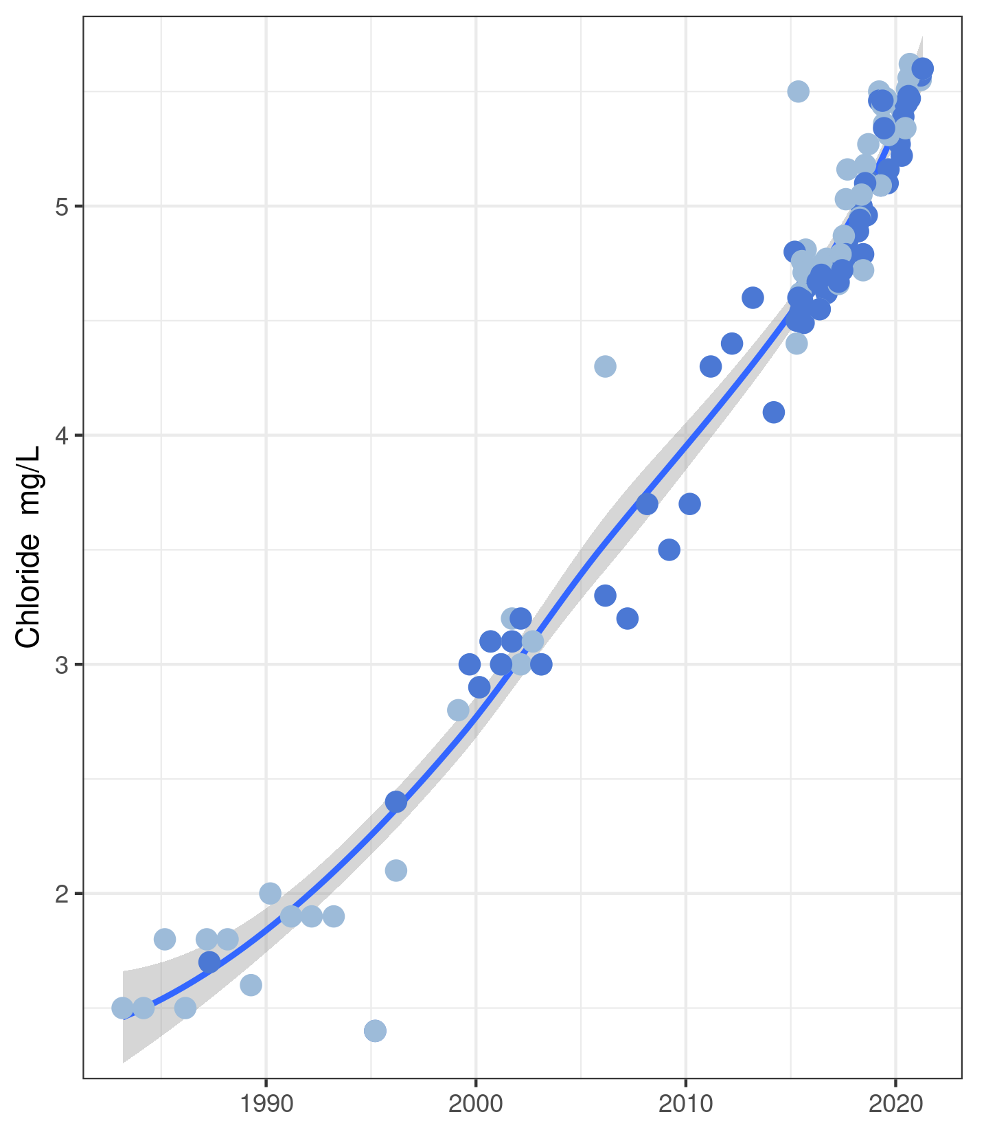
Long-term monitoring of Kalamalka Lake has been ongoing for 20 years. This extensive database has enabled water suppliers to identify changes in their water supply and quickly address them. One…
Water Supplier uses Sampling Results to “Cattle-ize” Ministerial Action in Lake Country
The District of Lake Country used complaints, substantiated by sampling results and watershed monitoring, to improve source water protection in the Oyama Creek Community Watershed. Complaints by the District to…
City of West Kelowna Long-Term Monitoring Identified Unprecedented Turbidity
Long-term data helped identify the cause of abrupt high turbidity in a reservoir that had been stable for 32 years of monitoring. This case involved a change in the amount…
Links
BC Wildlife Federation Conservation App. https://bcwf.bc.ca/initiatives/conservation-app/#:~:text=Conservation%20at%20your%20fingertips,now%20easier%20to%20use%20offline.
FrontCounter B.C. http://www.frontcounterbc.gov.bc.ca/
Geography Open Textbook, 2014. British Columbia in a Global Context: Tools for Spatial Data Collection and Utilization. https://opentextbc.ca/geography/back-matter/tools-for-spatial-data-collection-and-utilization/
Government of British Columbia, Share Your Water Data. https://www2.gov.bc.ca/gov/content/environment/air-land-water/water/water-science-data/water-data-tools/real-time-water-data-reporting/water-data-submission
Government of British Columbia, EcoCat Ecological Reports Catalogue. https://www2.gov.bc.ca/gov/content/environment/research-monitoring-reporting/libraries-publication-catalogues/ecocat
Government of British Columbia, iMapBC. https://www2.gov.bc.ca/gov/content/data/geographic-data-services/web-based-mapping/imapbc
Government of British Columbia, Environmental Monitoring System (EMS)
The Interactive Map is a map of all monitoring data/sites that have been uploaded to BC’s EMS database. You can navigate to location you are interested in and click on the dot. This will bring up a menu that allows you to download or view data for that site. It can be accessed at the following website: https://governmentofbc.maps.arcgis.com/apps/webappviewer/index.html?id=0ecd608e27ec45cd923bdcfeefba00a7
The Web Reporting Main Menu is a less visual way to access the same data. You can use the data search and download button to download the data you are interested in. Sites are all coded by an EMS number, and you can search by that number or a name. This interface allows you to download data for multiple sites at the same time. It can be accessed at the following website: https://a100.gov.bc.ca/pub/ems/mainmenu.do?userAction=mainmenu
Guidance on how to use the system and help emails can be found here:
- https://www2.gov.bc.ca/gov/content/environment/research-monitoring-reporting/monitoring/environmental-monitoring-system
- https://www2.gov.bc.ca/gov/content/environment/air-land-water/water/water-quality/water-quality-monitoring/water-quality-monitoring-documents
- https://www2.gov.bc.ca/gov/content/environment/research-monitoring-reporting/monitoring/lake-monitoring/bc-lake-monitoring-network/other-lake-monitoring-activities/okanagan-lake-collaborative-monitoring
- https://www2.gov.bc.ca/gov/content/environment/air-land-water/water/water-quality/water-quality-objectives/thompson-okanagan-region-water-quality-objectives
Government of British Columbia, Real-Time Water Data. https://www2.gov.bc.ca/gov/content/environment/air-land-water/water/water-science-data/water-data-tools/real-time-water-data-reporting
Government of British Columbia, Report All Poachers and Polluters. https://www2.gov.bc.ca/gov/content/environment/natural-resource-stewardship/natural-resource-law-enforcement/conservation-officer-service/cos-rapp
Okanagan Basin Water Board, Water Quality Database. https://www.obwb.ca/wqdb/
Real-Time Hydrometric Data Map Search, Water Survey of Canada. https://wateroffice.ec.gc.ca/google_map/google_map_e.html?map_type=real_time&search_type=province&province=BC