A common challenge in source protection is that water suppliers often do not have authority in source watersheds.
This tool provides guidance on the plans, policies and bylaws that are within local government jurisdiction, which can be used to support source water protection.
Table 9 describes the legislative and policy tools available to municipalities, regional districts and improvement/irrigation districts.
Table 9: Comparison of characteristics for local roles and responsibilities
Characteristics
Municipality
Regional District
Improvement District
MAIN LEGISLATION
Community Charter and Local Government Act
Local Government Act
Local Government Act, Part 17
REPORTING TO THE PUBLIC
Council meetings and minutes
Public notices
Annual report
Board meetings and minutes
Public notices
Board meetings and minutes
Annual general meeting
BYLAWS INVOLVED IN WATER PROVISION
Official Community Plan
Zoning Bylaw
Subdivision and Servicing Bylaw
Water Bylaw
Regional Growth Strategy
Official Community Plans
Zoning Bylaws
Subdivision Servicing Bylaws
Local Area Service Bylaws
Restricted to bylaws that regulate the services operated by the Improvement District
FORMS OF REVENUE TO FINANCE WATER
Property taxes
Local service area taxes
Development cost charges
Fees and charges
Reserve funds
Latecomer charges and cost recovery for excess or extended services
Grant programs
Local service area taxes
Development cost charges
Fees and charges
Reserve funds
Latecomer charges and cost recovery for excess or extended services
Grant programs
Taxes on the basis of parcels, values, or areas
User rates and charges
Developer charges (capital expenditure charges)
Reserve funds
Sinking funds
Connection charges
Latecomer charges and cost recovery for excess or extended services
(adapted from the AGLG Perspective Series Booklet)
Note: Regional governments can also indirectly protect source water via the Riparian Areas Protection Regulation (RAPR), although its applicability across watershed levels is limited. The RAPR does not apply to: farming activities; mining; hydro facilities; forestry activities; federal and First Nation lands; parks and parkland; and institutional developments.
How to use this tool
Refer to Table 10 to learn how common local government plans, policies, and bylaws can be used to protect drinking water sources.
If your community already has many of these documents in place, use the information provided to add or improve source water protection measures during updates.
Pro Tip: Check out this database of toolkits and guides that provide more detail on bylaws and regulatory approaches to ecosystem protection available to local governments. Make sure to review the Green Bylaws Toolkit, which presents a series of local government policy and planning tools for ecosystem protection and a collection of sample bylaw wording from around BC that can be used by communities developing their own bylaws.
Table 10: Local government plans, policies, and bylaws to support source water protection
Type of plan,
policy or bylaw
How to use for
source water protection
Regional Growth Strategy (RGS)
WHAT IT IS:
- Directs long-term planning (minimum 20 years) for regional district and municipal official community plans
- Sets commitments made by a regional district and its member municipalities on social, economic, and environmental goals and priority actions
- Promotes efficient use of water resources to support and enhance regional sustainability and resilience
- Supports data collection and mapping
USE IT TO:
- Include policies related to source water protection in RGS chapters focused on land, water resources, health, climate and ecosystems
- Designate urban growth boundaries and concentrate a high percentage of development where water is available
- Coordinate the acquisition and protection of sensitive ecosystems of regional significance
- Integrate the management of shared watersheds
- Discourage development in areas where water quantity or quality is insufficient
- Encourage watershed and aquifer mapping, groundwater and surface water monitoring, and watershed management plans
- Designate groundwater recharge areas or aquifer protection areas
- Encourage the adoption of water conservation bylaws and demand management programs
- Promote rainwater infiltration
STRENGTH:
Promotes consensus and coordination among communities
LIMITATION:
Lacks specificity and enforceability
Official Community Plan (OCP)
WHAT IT IS:
- Describes the long-term vision of the community
- Sets a general direction for objectives and policies that guide decisions on planning and land use management
USE IT TO:
- Map sensitive ecosystems and designate environmentally sensitive areas (ESAs)
- Provide policies on the areas that impact source waters:
- Natural environment – describe how the local government will protect existing natural ecosystems, lakes, streams, wetlands, groundwater, and sensitive drainage areas, and restore degraded ecosystems
- Climate change – describe how to adapt to changes in water quantity and quality
- Infrastructure – describe stormwater, drinking water, wastewater, water intake zones, flooding, and green infrastructure plans for the community
- Growth – designate land uses and prescribe densities that concentrate development in areas away from sensitive ecosystems; establish amenity bonus and density policies; and protect green infrastructure
- Commit to a collaborative and integrated watershed management approach to coordinate action on the community water supply, rainwater management, green infrastructure, and government regulations
- Specify site design that maintains natural hydrological cycles
- Require development proposals to conform to BMPs Set out policies for land acquisition
- Include designations of environmental Development Permit Areas (see below) their justifications and detailed guidelines for development in these areas (e.g., environmental assessment process, riparian setback, erosion and sediment control, vegetation protection, and landscaping requirements)
STRENGTH:
Contains policies with which regulatory bylaws must not be in direct conflict (e.g., an OCP that addresses water protection is a good foundation for bylaws that contain specific and enforceable standards and policies that protect water)
LIMITATION:
Often treated as a policy that does not have direct impact on daily operations; typically, does not apply to Crown lands where many of the headwaters and key areas for source protection are located
Type of plan,
policy or bylaw
How to use for
source water protection
Development Permit Area (DPA)
(designated within Official Community Plans)
WHAT IT IS:
- Designates area(s) where special guidelines apply through an OCP
- The Local Government Act enables local governments to designate DPA(s) for one or more of the following purposes that could act to protect source waters:
- Protection of the natural environment, its ecosystems and biological diversity
- Protection of farming
- Protection of development from hazardous condition (e.g., flooding)
- Establishment of objectives to promote water conservation
USE IT TO:
- Regulate development around streams, lakes, wetlands, sensitive drainage areas, and groundwater protection zones
- Prohibit site disturbance before development approval
- Specify area(s) of land that must remain free of development, except in accordance with any conditions contained in the permit
- Require construction of works to preserve, protect, restore or enhance natural watercourses or other specific natural features
- Specify protection measures, including planting or retaining vegetation to conserve, protect, restore or enhance sensitive ecosystems, or control drainage and erosion
- Require an environmental impact assessment and specialized information before the permit is issued
- Create guidelines for BMPs
STRENGTH:
Specifies how development can occur on a site, while protecting the natural environment; more fine-grained tool than standard zoning
LIMITATION:
Requires additional staff expertise and time to review applications and set permit conditions
Zoning Bylaw
WHAT IT IS:
- Regulates the use, density, and development standards of property
- Sets standards on aspects of development that impact water resources on the site or in the area
USE IT TO:
- Preserve large lots located outside of designated urban area
- Set density bonuses for specific zones
- For each zone, establish the maximum percentage of the land area that impermeable material may cover Include requirements for parks, density bonuses, and clustering of new house sites in rezoning.
STRENGTH:
Provides several ways (e.g., lot sizes, density, setbacks, permitted uses) to direct development away from sensitive ecosystems, including watercourses and aquifers
LIMITATION:
Lacks details to respond to site-specific ecological conditions
Subdivision and Development Servicing Bylaw
WHAT IT IS:
- Sets the standards and specifications for works and services, and sets out the application procedures in connection with the subdivision and development of land within local government boundaries
USE IT TO:
- Provide stormwater runoff (drainage and infiltration) requirements: include a rainwater management design and policy manual; require that post-development site runoff match pre-development levels; include standards for erosion and sediment controls; require the inclusion of climate change in projections
- Include rural landscaping and road design requirements that protect ecosystems: no curbs; shallow drainage swales; narrow pavement; significant revegetation
- Require wells to be closed when property gets connected to community water system (this can also be done by independent bylaw)
- Require bonding for future operations and maintenance of larger systems
- Adopt policy and design manuals focused on rainwater infiltration, low impact development, and green infrastructure
STRENGTH:
Can support water protection by including standards for on-site infiltration, erosion control, low impact development, and water conservation practices and requesting additional information in support of an application (e.g., environmental assessment)
LIMITATION:
Does not respond to site-specific ecological considerations and only triggered when new subdivision or development occurs
Type of plan,
policy or bylaw
How to use for
source water protection
Regulatory Bylaw(s)
WHAT IT IS:
- Establishes parameters for how a landowner may carry out an activity
USE IT TO:
- Regulate landscaping, soil deposit and removal, tree protection, watercourse protection, pesticide use, invasive species, well closure, sanitary sewer storm drain, drainage, and flood hazards
STRENGTH:
Are proactive and reactive; can require landowners to obtain permits before carrying out activities that have an environmental impact and can enable staff to enforce the bylaw(s) through ticketing or court action
LIMITATION:
Potential for standards to be too stringent and costly to administer and can be difficult to enforce
Master Plan(s)
WHAT IT IS:
- Provides a road map of projects and programs for local governments to undertake in the short, medium and long term to make sure a community keeps pace with population growth, delivers adequate services, and protects public health and the environment
- Examples include water, stormwater and drainage, liquid waste, asset management, and parks and recreation
USE IT TO:
- Identify and prioritize projects that will help improve water quality and protect sources
STRENGTH:
Gives the community the ability to make informed decisions that uses financial and other resources effectively
LIMITATION:
Can lead to problems if not well conceived or too inflexible
Other Water-Related Plans
Standalone plans such as water conservation plans, rainwater management plans, drought management plans, integrated lake management plans, and floodplain management plans can be used to protect water sources.
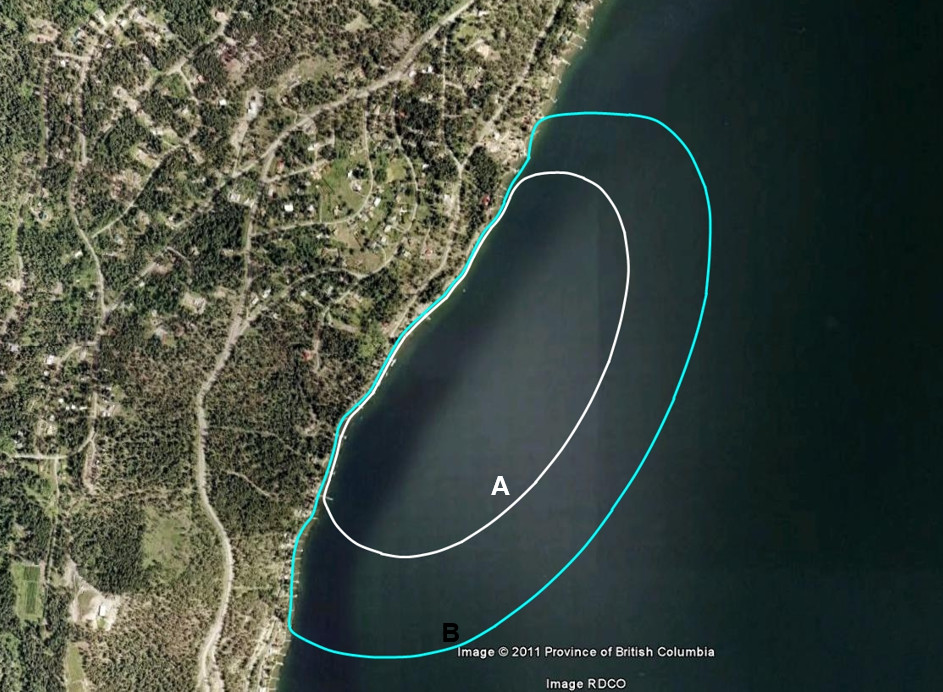
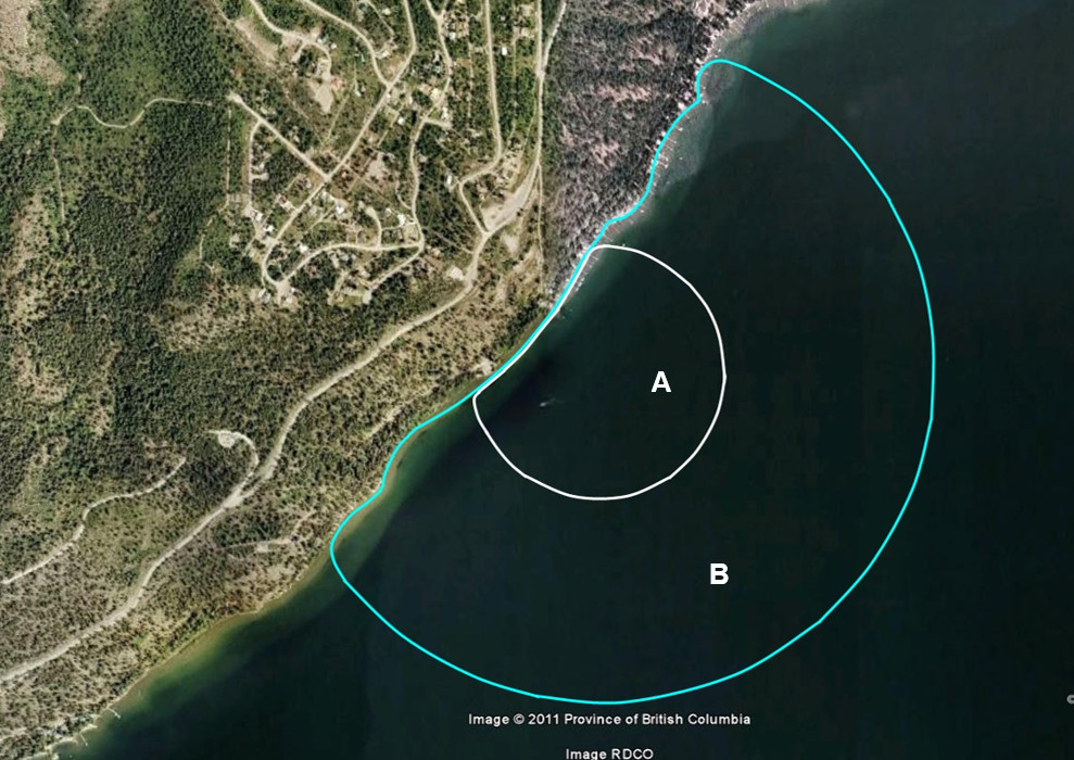
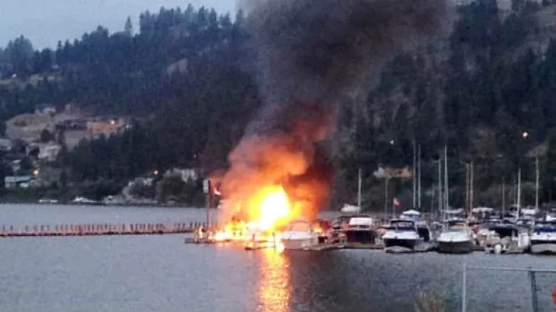
Intake Protection Zones
An Intake Protection Zone (IPZ) is developed based on typical water travel times at a specific intake to provide 2 hours of travel time between a potential contaminant and the intake. IPZs were developed as part of Okanagan mainstem lake source assessments at the encouragement of Interior Health. However, gaining legal recognition has been slow. Marinas and hazardous land uses continue to be built within IPZs in the Okanagan. If a Licence of Occupation (LoO) is sought, the Government of British Columbia usually requires that the management of all dock licensing within the LoO also be managed by the municipality. Nonetheless, inclusion in an Official Community Plan and municipal mapping have also been pursued to help guide development and activities within IPZs. For example, the City of Kelowna has included their four IPZs in their 2040 OCP.

Case Studies
Lake Windermere Management Plan
The Lake Windermere Management Plan was initiated by the Regional District of East Kootenay (RDEK) in November 2008 to address concerns that increasing development and use could lead to a…
City of Burnaby Streamside Protection and Enhancement Areas and Guide for Developing Near Streams
The City of Burnaby Zoning Bylaw defines the Streamside Protection and Enhancement Area (see 6.23 on page 18), which mandates setbacks for development from streams, ravines, wetlands and lakeshores. In…
District of North Vancouver Environmental Protection and Preservation Bylaw
The District of North Vancouver Environmental Protection and Preservation Bylaw regulates the protection, preservation and conservation of the natural environment and ecological systems including watercourses, trees, soils, and lands. It…
City of Metchosin Protection and Management of Rainwater Bylaw
The City of Metchosin Bylaw for the Protection and Management of Rain Water regulates the use and development of land to minimize the impact on a watershed by emphasizing the…
City of Kelowna Well Regulation Bylaw
The City of Kelowna Well Regulation Bylaw regulates the disconnection and closure of wells on properties connected to the City Water Utility. The bylaw includes options for water well owners…
Enhancing Climate Resilience of Subdivision and Development Servicing Bylaws in the Columbia Basin
The Enhancing climate resilience of Subdivision and Development Servicing (SDS) Bylaws in the Columbia Basin: A guidance document was designed to assist communities in the Columbia Basin in updating their…
City of Nanaimo Official Community Plan and Zoning Bylaw Watercourse Leave Strips
The City of Nanaimo protects watercourse riparian areas using two regulatory mechanisms. Section 6.3 of the City of Nanaimo Zoning Bylaw prohibits the development or the alteration of a leave…
Village of Cumberland Development Permit Area for Groundwater Protection
The Village of Cumberland DPA 2 – Groundwater Protection (p. 99) regulates development in a manner that protects, sustains, or enhances the quality and quantity of ground water sources for…
Official Community Plan Policies Supporting Climate Resilience
The Official Community Plan Policies Supporting Climate Resilience guide provides local government with guidance and examples for putting climate resilient policies into official community plans and development permit areas guidelines….
District of Highlands Official Community Plan
The District of Highlands Official Community Plan states that all land use decisions must consider water (Section 2.1). Numerous sections in the OCP provide objectives and policy direction related to…
Comox Valley Regional District Regional Growth Strategy
The Comox Valley Regional District Regional Growth Strategy has a strong emphasis on protecting drinking water and managing stormwater. Objective 5-B and its five policies call for professional reports that…
Metro Vancouver 2040 Shaping our Future Regional Growth Strategy
Metro Vancouver’s Regional Growth Strategy sets out Conservation and Recreation areas, which are intended to protect significant ecological and recreation assets, including drinking water. Goal 3 Protect the Environment and…
Links
Preparing for Climate Change: An Implementation Guide for Local Governments in British Columbia, published in 2012 by West Coast Environmental Law. https://www.wcel.org/sites/default/files/publications/WCEL_climate_change_FINAL.pdf
Green Bylaws Toolkit. https://stewardshipcentrebc.ca/green-bylaws-toolkit/